Photo by Gordon Campbell | At Altitude Gallery
Smith Island
Owned and managed by: The Nature Conservancy Virginia Coast Reserve.
Smith Island is open year-round to the public for low-impact, recreational day use, such as hiking, bird watching, surf fishing and photography. All areas above the high tide line are closed April through August. Please help protect sensitive habitats and wildlife by observing all visitation policies and seasonal restrictions.
Visiting Smith Island
The Seaside is a dynamic landscape with constantly shifting tides, sands and weather. Safety is a top concern when visiting this remote area with limited accessibility and services. Stay alert, come prepared and be aware of island use policies.
Open for recreational DAY use:
![]()
![]()
![]()
![]()
Prohibited at ALL times:
![]()
![]()
![]()
![]()
Seasonal restrictions (April through August):
For information about our policies, please contact the Virginia Coast Reserve office:
- Call us at (757) 442-3049
- Visit our website
Suggested access points
Smith Island is most easily accessed via the inlet beach at the south end of the island (Smith Island Inlet). Access to other parts of the island requires extensive knowledge of the waterways and is not recommended for inexperienced visitors. The Cape Charles Lighthouse located at the southern end of the island is owned and managed by the U.S. Coast Guard and is not open to the public.
About Smith Island
Situated at the mouth of the Chesapeake Bay, Smith Island is easily recognized by the Cape Charles Lighthouse on its southern end – not to be confused with the Smith Point Lighthouse on the western shore of the Chesapeake Bay. The Cape Charles Lighthouse is no longer operational and is owned and managed by the U.S. Coast Guard. It was actually the third lighthouse built on the island, the locations of the first two now lie under the ocean to the east.
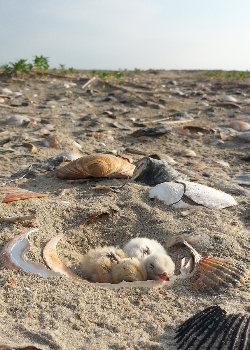
Smith Island’s unique geography is characterized by highly dynamic, active beachfront along the northern three-quarters of the island and now forested sets of ancient beach ridges along the interior of the southern quarter of the island. The island is one of Virginia’ most important sites for beach nesting birds, particularly along the dynamic habitats at the north end where island migration and overwash events maintain the open beach habitats for nesting. Visitors can often see aquaculture crews at work within the shallow bays and sand flats that lie to the west of the island. These are incredibly important areas that make it possible for the Eastern Shore to be one of the biggest hard clam producers in the country – boaters should be alert for signs and stakes that mark the sensitive aquaculture areas within the coastal bays.
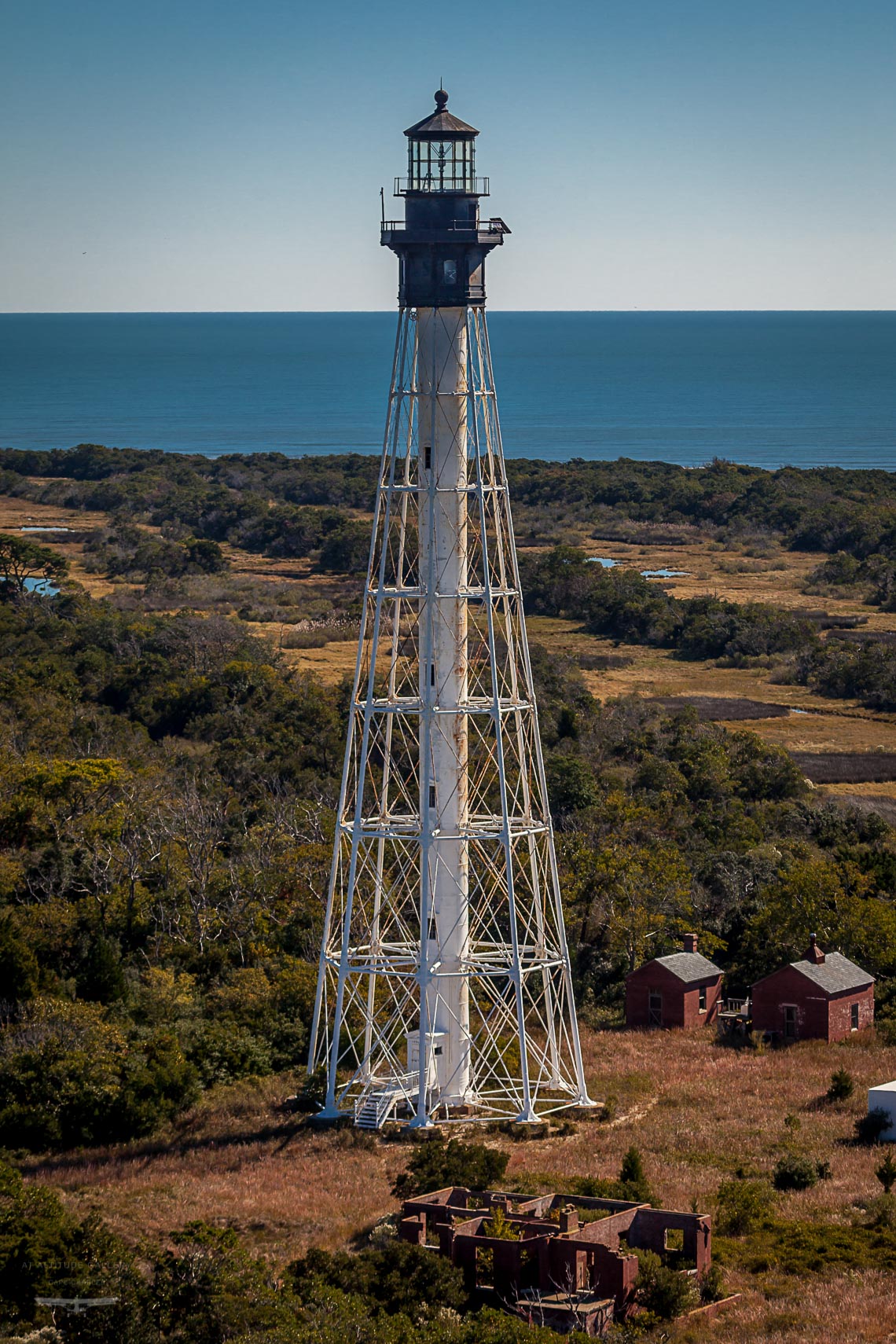
Photo by Gordon Campbell | At Altitude Gallery
Discover a Coastal Wilderness
The Atlantic coastline of Virginia’s Eastern Shore is a unique coastal wilderness that spans 70 miles from the Virginia/Maryland border to the mouth of the Chesapeake Bay. The region is characterized by vast, mostly undeveloped marshes, barrier island beaches and coastal lagoons that support globally important populations of migratory birds, are the site of intensive large scale oyster reef and eelgrass restoration projects, and provide extensive recreation opportunities in remote settings. Learn more about the natural history of this amazing coastal landscape.
OWNERSHIP AND LAND MANAGEMENT
The Nature Conservancy Virginia Coast Reserve
The Nature Conservancy is a global conservation organization dedicated to conserving the lands and waters on which all life depends. Guided by science, the Conservancy creates innovative, on-the-ground solutions to our world’s toughest challenges so that nature and people can thrive together.
The Virginia Coast Reserve (VCR) is a landscape program within the Virginia Chapter of the Conservancy that is headquartered in Nassawadox, Virginia on the Eastern Shore. VCR is made up of 14 barrier and marsh islands, extensive salt marshes and several mainland properties including the Brownsville Preserve. Programs at VCR address conservation topics on the Eastern Shore such as migratory bird conservation, marine habitat restoration, coastal resilience, land protection and outreach and education. VCR works collaboratively with federal and state partners to manage The Nature Conservancy’s properties, including the barrier islands and Brownsville Preserve, to ensure the protection of sensitive natural resources while also accommodating for low-impact visitor use.
Explore Our Seaside Partners
The seaside of Virginia’s Eastern Shore is almost entirely owned and managed by non-profit, state and federal agencies. These partners share the common goal of protecting natural resources, while balancing sustainable recreational and economic use of the seaside. Learn more about our partnership.